Sample — a demonstration landing page built by Victory Marketing Solutions. Aurelia Gold Corp. is a fictional issuer; every figure is illustrative and nothing here is investment advice. Back to Victory →
TSXV: AURQOTCQB: AURQF

Corporate presentation · Kestrel Project

High-grade Abitibi gold, 4 km from a running mill.

Kestrel is an outcropping, road-accessible quartz–carbonate vein array on a corridor that has produced nine million ounces — now confirmed by independent labs as free-milling ore recovering 96.4% of contained gold on a conventional flowsheet.

  • Gold
  • Free-milling
  • Toll-mill ready
  • Open at depth
Flagship
Kestrel Project, Ontario
Historical resource*
1.87 M oz @ 6.4 g/t Au
Metallurgical recovery
96.4%
Tenure
68 claims · 3,180 ha
*Historical estimate, not current and not NI 43-101 compliant. See disclosure.

The setting

Four kilometres from a mill that has been running for thirty years.

The Kestrel property sits in the Abitibi Greenstone Belt in northeastern Ontario, 4 km along strike from the Redtail Gold Mine — a continuously operating underground gold mine and 2,400 tonne-per-day mill complex that has poured gold every year since 1996.[1]

Kestrel is hosted on the same regional structure that controls mineralisation at Redtail: the Kestrel–Redtail Deformation Corridor, a crustal-scale break that has produced more than 9 million ounces of gold along its 60 km length. Kestrel occupies 11 km of that corridor and has never been drilled below 300 m vertical.[1]

LocationTimiskaming District, Ontario, Canada
Distance to Redtail mill4 km along strike
Nearest townKirkbride — 22 km, full mining services
AccessYear-round, paved highway plus 6 km gravel
PowerGrid line crosses the property — low-cost hydro
Tenure68 unpatented claims, 3,180 ha (7,858 acres)

The mineralised system daylights. Quartz–carbonate veining with visible gold is exposed in outcrop and historic trenches over a strike length of 2.6 km, beneath a metre or less of glacial till.[1]

Location, access and infrastructure

Highway, mill, grid power and a corridor with a track record.

Redtail ore is trucked and milled on site, with doré shipped to a refinery in Ottawa. Kestrel sits inside that same infrastructure envelope, on the same road.[1]

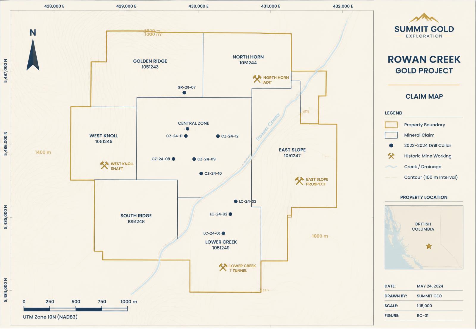
Plan map of the Kestrel property claim block in the Abitibi Greenstone Belt of Ontario, showing the outcropping vein array, the Redtail mill 4 km along strike, the highway access and the grid power line
Fig. 1Kestrel property, claim block and regional infrastructure. Illustrative sample figure — geometry is schematic.
Kirkbride
22 km, mining services
Redtail mill
4 km along strike
Road access
Year-round, paved + 6 km
Power
Grid line on property

Want the deep drill assays when they land? Join the list →

The company

A small team advancing an asset that a major already walked past once.

Aurelia Gold Corp. is a junior exploration company incorporated in Ontario — a group of geologists and mine builders assembled to acquire and de-risk high-grade gold assets in tier-one jurisdictions with existing infrastructure and a low barrier to entry.[1]

The company holds a 100% interest in the Kestrel property, acquired from Northgate Consolidated in 2023, and a 100% interest in the Sable Creek property, 45 km north, in the same greenstone belt.[1]

ListingsTSXV: AURQ · OTCQB: AURQF · FSE: 9K2
FlagshipKestrel gold project, Ontario
Second assetSable Creek — 9,400 acres, 100% owned
JurisdictionOntario — top-five ranked mining jurisdiction

Phase 1 metallurgy

The results are in: free-milling gold, no refractory penalty.

On March 12, 2026, Blackwater Metallurgical Laboratories completed a detailed mineralogical and recovery study on 412 kg of composite material drawn from four zones across the Kestrel system.[2]

Roughly 91% of contained gold reports as free, liberated grains at a grind of 75 microns. Gravity concentration alone recovered 62% of the gold; conventional cyanide leach of the gravity tail lifted total recovery to 96.4%. Arsenic, antimony and organic carbon — the three things that turn a gold deposit into a refractory problem — are present at trace levels only.[2]

Gold liberation at 75 µm91%
Gravity recovery62%
Total recovery (gravity + leach)96.4%
Leach residence time24 hours
Arsenic / antimony / organic carbonTrace

Free-milling ore means a conventional flowsheet, no roaster, no pressure oxidation, and — critically — ore that the Redtail mill 4 km away is already built to treat.[2]

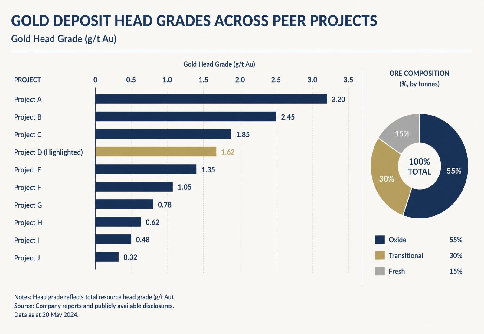
How Kestrel's grade compares

Higher numbers are better. Kestrel's are high.

Chart comparing Kestrel head grade in grams per tonne against peer Abitibi gold projects, with an ore composition breakdown by oxide, transitional and fresh material
Fig. 2Head grade benchmark and ore composition. Illustrative sample figure based on the Phase 1 study.

Why Kestrel is different

A structurally controlled vein system — not a bulk-tonnage halo.

Most junior gold projects in the belt are low-grade disseminated systems that need enormous tonnage and a new mill to work. Kestrel is a structurally controlled quartz–carbonate vein array: narrow, steeply dipping, continuous, and high grade.[2]

That changes the entire economic question. The asset does not need to justify a billion-dollar build; it needs to justify a haul truck and a toll-milling agreement.

The Phase 1 work also confirmed that gold at Kestrel is associated with fine pyrite along vein selvages rather than locked inside arsenopyrite. The gold is where a conventional circuit can reach it, and the deleterious elements sit in the wall rock rather than in the ore mineral.[2]

The Blackwater results remove the two questions every gold junior gets asked: can you recover it, and can you sell it. Ninety-six percent recovery on a conventional flowsheet, four kilometres from an operating mill, answers both.

Marisol Kavanagh, President & CEO, Aurelia Gold Corp.

One deposit, two development paths

Toll-mill first, standalone later — optionality, not a bet.

One of the most significant findings of the Phase 1 work is that Kestrel material is directly compatible with the existing Redtail circuit. That gives the project a near-term, low-capital route to cash flow while the deeper resource is drilled out — reducing dependence on a single financing window.[2]

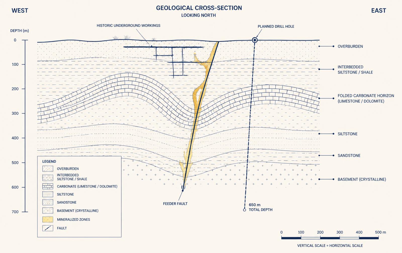
Vertical cross-section through the Kestrel vein array showing steeply dipping quartz-carbonate veins, historical drill hole traces to 300 metres and the untested target zone below
Fig. 3Cross-section, historical drilling and the untested zone below 300 m. Illustrative sample figure.
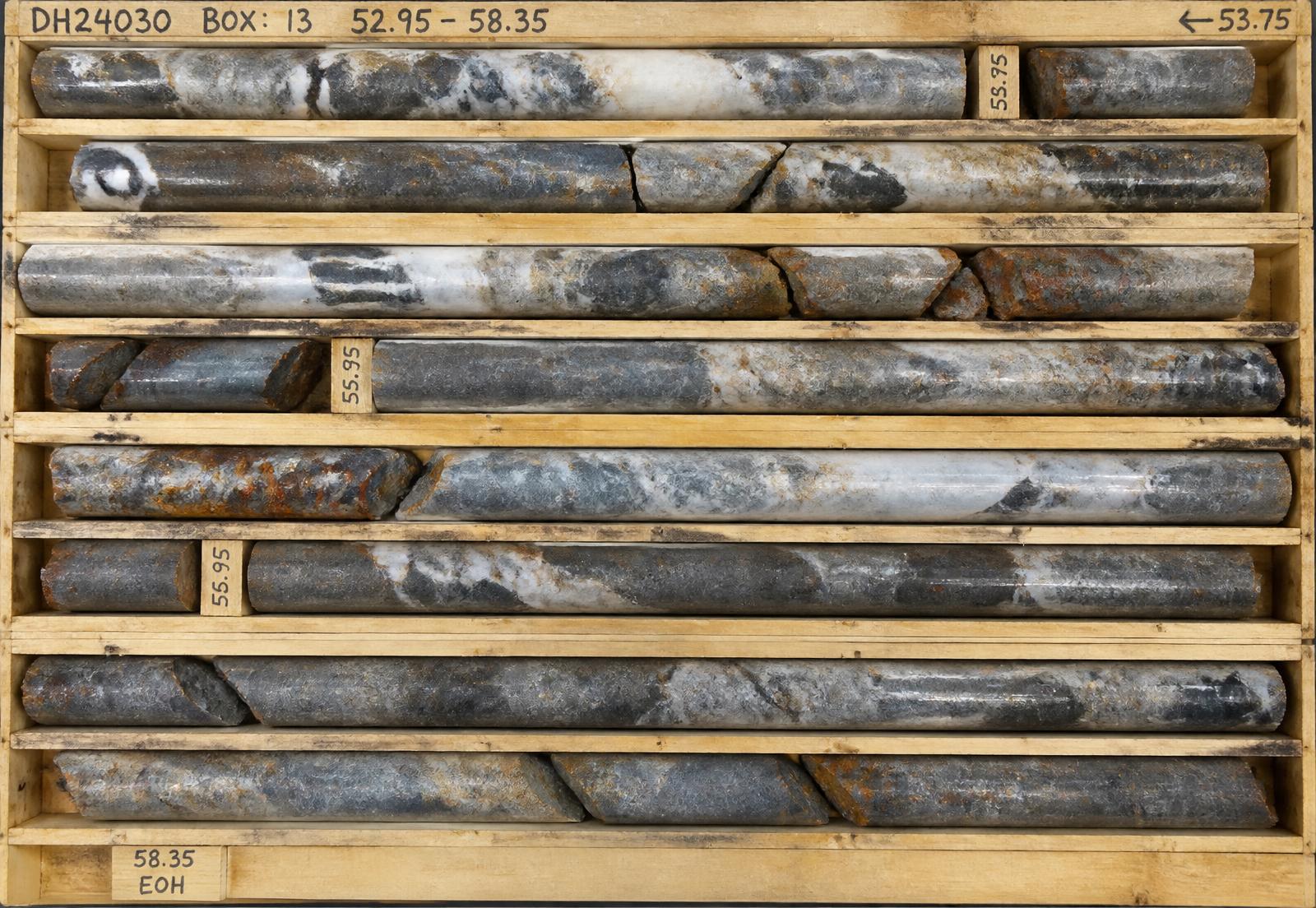
Diamond drill core in a core box showing quartz-carbonate vein material with sulphide selvages cutting dark mafic volcanic host rock
Fig. 4Drill core, vein array intercept. Representative sample imagery.

Want the deep drill assays when they land? Join the list →

The geology

An Archean shear system with a gold-only signature.

The Kestrel deposit is hosted in Archean mafic volcanic rocks of the Blake River assemblage, cut by a series of steeply north-dipping quartz–carbonate–tourmaline veins developed along a second-order splay off the Kestrel–Redtail Deformation Corridor.[1]

Alteration is classic and mappable: iron-carbonate, sericite and fine disseminated pyrite haloing the veins over 3–12 m. Gold correlates with pyrite content and with vein density, and mineralisation remains open along strike to the east and to depth below 300 m — the limit of all historical drilling.[1]

In the core

Quartz, pyrite and visible gold, in one rock.

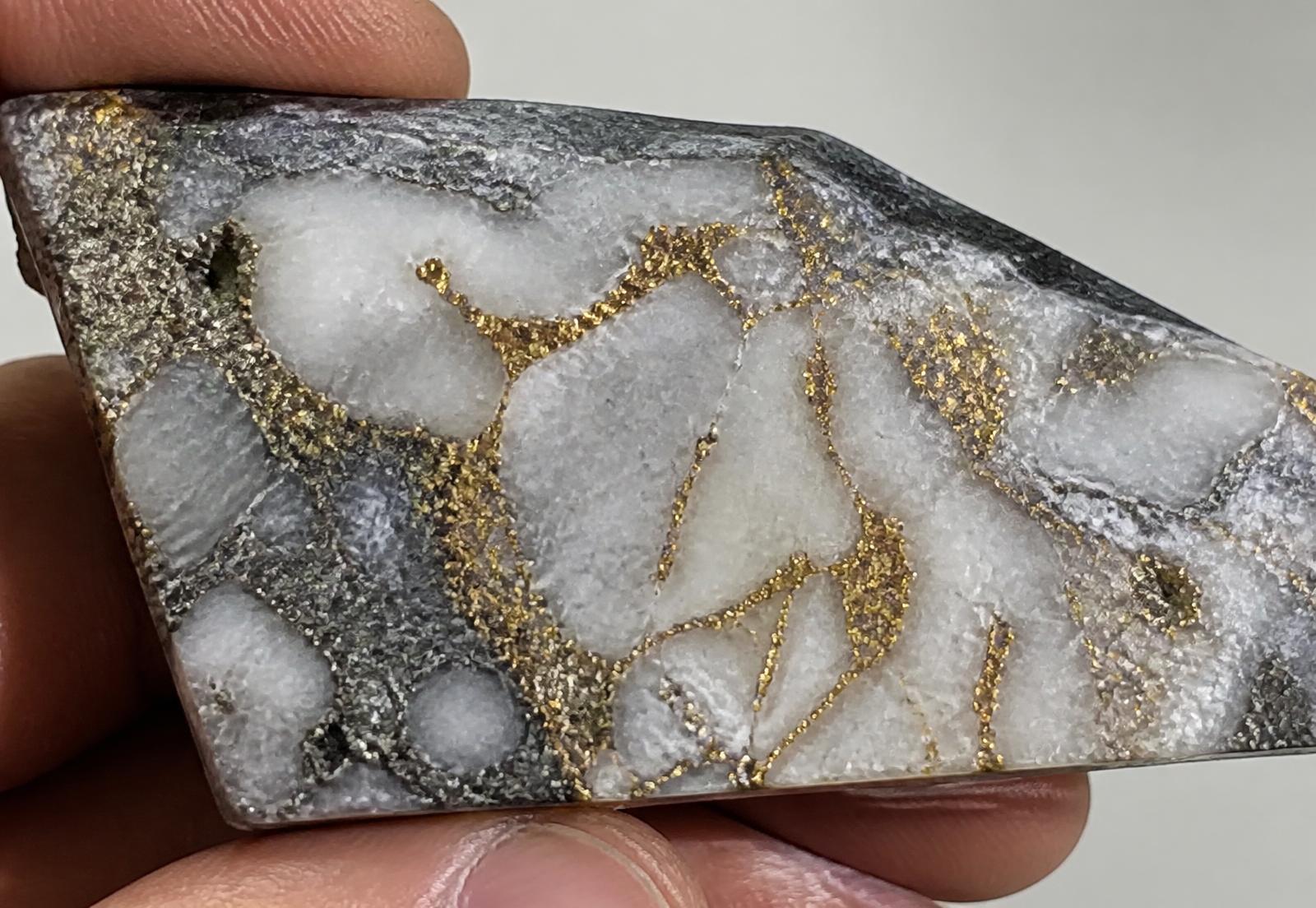
Close-up photograph of drill core showing a quartz-carbonate vein with fine pyrite along the selvage and specks of visible gold
Fig. 5Vein selvage with fine pyrite and visible gold. Representative sample imagery.
TextureWhat it carries
Massive quartz veinAu, highest grade
Pyritic selvageAu with sulphide
Carbonate–sericite haloLow-grade Au envelope
Mafic wall rockHosts trace As, Sb

Texture descriptions summarise the Phase 1 mineralogical findings.[2]

History

Seventy years of work that stopped every time gold did.

1948 – 1969

  • Kestrel showing discovered by prospector Léo Marchand following the corridor north from Redtail.
  • First work on the property: 14 diamond drill holes totalling 3,860 feet, all shallow.
  • Northgate Consolidated completes trenching over 1.4 km of strike and reports visible gold in five trenches.

1970 – 2003

  • Engineering report completed with a historical mineral resource estimate.
  • Historical resource based on shallow drilling only, restricted to the western half of the vein array.
  • Two bulk samples and five metallurgical programs conducted — all positive — plus a preliminary mining scoping study.

2004 – Present

  • Verification work based on 84 sample sites, with 3 drill holes (206 core samples) confirming grade continuity across the array.
  • Channel samples averaged 6.8 g/t Au over 3.1 m across the entire exposed strike length.
  • Locations of historical drill collars, trenches and bulk sample sites verified and re-surveyed in 2024.

Between 1951 and 1978 the vein array was tested with 41 diamond drill holes and two bulk sample sites, defining a significant historical mineral resource (Marchand, 1978). 84 surface and channel sites were tested in 2011 to confirm grade continuity (Okada, 2011), and confirmation sampling, re-logging and collar surveying were completed in 2024 (Fenwick, 2024).[3][5]

Historical resource

1.87 million ounces at 6.4 g/t Au — historical, and stated as such.

The project has 41 drill holes to date, with significant gold intercepts including:[3]

1951 drilling8.42 g/t / 4.6 m · 6.15 g/t / 7.2 m · 5.90 g/t / 5.1 m
1978 drilling22.60 g/t / 2.1 m · 14.35 g/t / 3.8 m · 11.04 g/t / 4.4 m

An engineering report by Marchand (1978) cited a historical resource of 9.1 million tonnes at 6.4 g/t Au for 1.87 million contained ounces, based on both the 1950s and 1978 drilling programs. The 1978 program comprised more definitive drilling and assaying of the eastern extremity of the vein array, defining a separate 420 m strike length — roughly one sixth of the mapped surface exposure — of 1.4 million tonnes at 9.8 g/t Au within the larger tonnage reported.[3]

Whole vein array (historical)9.1 Mt @ 6.4 g/t Au · 1.87 M oz contained
Eastern 420 m strike (historical)1.4 Mt @ 9.8 g/t Au · 441 k oz contained
Drill holes to date41
SourceMarchand (1978), GM41277

These "resources" are historical in nature and should not be relied upon, nor treated as a current estimate. It is unlikely they conform to current NI 43-101 requirements or follow CIM Definition Standards, and they have not been verified to determine their relevance or reliability. Originally reported in short tons at 0.187 oz/ton, converted here to metric tonnes and grams per tonne at equivalent grades. These historical "resources" are reported without any specific categories, which does not conform to current NI 43-101 requirements, and any comparison is not a valid comparison. A qualified person (QP) has not done sufficient work to classify the estimate as current, and the company is not treating the historical estimate as a current mineral resource. Results are presented for exploration targeting only. Aurelia Gold Corp. is a fictional issuer and all figures on this page are illustrative.

Historical metallurgy

Five programs, five decades, all pointing the same way.

Dominion Reduction Company (Whitlock, 1969)

Bench-scale amalgamation and cyanidation of trench composites returned 88% gold extraction at a 100 mesh grind, with no evidence of preg-robbing carbon.

Ontario Department of Mines Research Laboratory (Renaud, 1977)

Four tests concluded that a gravity concentrate could be produced from a 65% minus 200 mesh grind, recovering 58.2% of contained gold to 1.4% of mass before leaching.

Sandhurst Laboratories (1988)

Cyanide bottle-roll tests on 1978 drill core rejects returned 94.1% extraction over 48 hours with cyanide consumption of 0.42 kg/t — described in the report as unremarkable, which for a gold project is the highest compliment available.

Cormier Métallurgie (1996)

Flotation testwork produced a 61 g/t Au concentrate at 92% recovery, confirming a second viable route to a saleable product for higher-sulphide material at depth.

SGS Lakefield Resources (2004)

A combination of gravity and carbon-in-leach accomplished the best overall result. Grinding to 75 microns produced 96% total extraction; the report noted the flowsheet was directly compatible with existing regional milling capacity.

These metallurgical tests are historical in nature and should not be relied upon, nor treated as current data. It is unlikely they conform to current NI 43-101 requirements or follow CIM Definition Standards. A qualified person (QP) has not done sufficient work to classify the metallurgical tests as current, and the company is not treating these historical tests as current data. Results are presented for exploration targeting only.[4]

The road forward

Phase 1 is complete. Phase 2 is already under way.

Phase 1

Complete
  • Mineralogical and metallurgical characterisation — complete.
  • Confirmed free-milling ore type, 96.4% recovery, liberation size and deleterious element levels.
  • Established the toll-milling development thesis.

Phase 2

In progress
  • 12,000 m deep drill program testing the vein array from 300 m to 700 m vertical — the first ever below historical limits.
  • Rolling assays expected through the program; results released as received.
  • Maiden NI 43-101 resource estimate incorporating historical drilling, 2024 verification work and the new program.

Phase 2 focuses on the first deep drill program in the project's history — 12,000 m testing the vein array between 300 m and 700 m vertical, where the corridor at Redtail carries its highest grades. Assays are expected on a rolling basis, alongside a maiden NI 43-101 resource estimate incorporating the historical drilling, the 2024 verification work and the new program.[2]

Strategic context

Mills are the bottleneck. Kestrel is standing next to one.

Permitting and building a new gold mill in Ontario is a seven-to-ten year proposition. Regional mill capacity, meanwhile, is running below nameplate as mature operations work through declining head grades — which makes clean, high-grade, free-milling feed the scarcest input in the district.[1]

Aurelia's strategy is to develop Kestrel as a high-grade satellite feed source rather than a standalone build — trading dilution and decade-long timelines for a shorter, cheaper, toll-milled path to revenue.[1]

The project benefits from Ontario government support through the Junior Exploration Program, which co-funded the Phase 1 metallurgical testing at Blackwater. The combination of favourable ore chemistry, an existing mill within trucking distance and a corridor with 9 million ounces of production history positions Kestrel as a project with significant commercial and strategic potential.[1]

Second asset

Sable Creek — 9,400 acres on the same greenstone belt.

The property is located on a highly prospective geological unit in the Abitibi Greenstone Belt, 45 km north of Kestrel, and hosts two major deformation corridors. It has been historically underexplored for base and precious metals, with historical assays returning Au-Ag-Cu-Zn values.[1]

Ownership100% — Sable Creek property
ClaimsContiguous, 9,400 acres, Kirkbride camp
Technical reportNI 43-101 completed Sept. 2022
Proximity800 m east of Cavanagh Resources
Redtail historical production2.4 M oz @ 8.90 g/t Au*
Current M&I reserves (Cavanagh)310,400 oz @ 7.8 g/t Au*

*Redtail Gold Mine — Cavanagh Resources Inc., NI 43-101, 2022. Figures relate to the adjacent Cavanagh property, not to Aurelia Gold's claims.[6]

Historical drilling returned visible sulphide mineralisation. The presence of a VMS showing and Au-Ag-Cu-Zn mineralisation in the vicinity of the property indicates discovery potential. Geochemical targets run west (up to 189 ppm Cu in basalt-andesite assemblages), centre (up to 412 ppm Cu in the same assemblage) and east (up to 24 ppb Au, 147 ppm Cu and 233 ppm Zn in gabbro, felsic tuff and basalt-andesite assemblages).[1]

A low-altitude, high-resolution MAG survey has been completed over the entire property using tight line spacing — a configuration that has seen considerable success with neighbouring companies in the district. Total survey length was 1,140 line-km, and it will help define the numerous geophysical targets on the property for follow-up.[1]
The team

A junior exploration collective, run by people who have done it before.

Marisol Kavanagh, P.Geo

President, CEO & Director

A structural geologist with more than 28 years in Archean gold systems. She began her career mapping the Abitibi for a senior producer, went on to lead the exploration team that defined two multi-million-ounce deposits in Ontario and Québec, and has since served as VP Exploration and then CEO of two TSXV-listed juniors. She has raised more than $140 million in equity across public and private financings, negotiated three toll-milling agreements, and has taken projects from grassroots claim staking through to resource estimation and permitting.

Devon Achebe, CPA, CA

CFO

Founder of Achebe & Co. CPA (est. 2007), with over 19 years of experience providing financial reporting compliance services to junior listed issuers, as well as taxation, general accounting and advisory services to private and public companies. He has served as a director and officer of TSXV issuers and has been involved in reporting compliance related to flow-through financings, option agreements and acquisition transactions. He has been a member of the Chartered Professional Accountants of Ontario since 2006.

Anders Wex, P.Eng

Director

Holds a Bachelor of Applied Science in Mining Engineering from the University of Toronto and a Master of Engineering in Mineral Processing from Queen's University. He brings over 31 years of operating experience, including mill superintendent and general manager positions at three underground gold operations in Ontario, Nevada and Western Australia, and has commissioned two gravity–CIL circuits from the ground up.

Respectfully

The Kestrel property sits on the traditional territory of the Anishinaabe.

Aurelia Gold Corp. acknowledges that its Kestrel Property is located within the traditional territory of the Anishinaabe, including the communities of the Robinson-Huron Treaty area, and recognises and respects the enduring relationship these communities have with the lands, waters and resources. As activities advance in the region, the company is committed to building a respectful, transparent and long-term relationship with Indigenous communities based on mutual trust, collaboration and shared benefit.[1]

  • Support meaningful participation in project planning and development
  • Promote employment, training and business opportunities
  • Work collaboratively on environmental protection and monitoring
  • Respect cultural values, traditional knowledge and land use
  • Ensure ongoing dialogue throughout the life of the project

The approach is grounded in the principles of reconciliation; free, prior and informed consultation; and responsible resource development — on the belief that sustainable mining can only be achieved through genuine partnership with Indigenous peoples.[1]

Questions

What investors ask us first.

That 91% of contained gold is liberated at a 75 micron grind, that gravity alone recovers 62%, and that a conventional gravity plus cyanide leach circuit recovers 96.4% in 24 hours. Arsenic, antimony and organic carbon are present at trace levels only, so there is no refractory penalty.

The list

Project milestones go to the list before they go anywhere else.

Deep drill assays, the maiden NI 43-101, toll-milling progress and corporate developments. No third-party promotions. Unsubscribe any time.

Demonstration page built by Victory Marketing Solutions. Fictional issuer. Not investment advice.

Sources and disclosure

  1. [1]Aurelia Gold Corp., corporate presentation and Kestrel Property disclosure (2026). Fictional issuer created for demonstration purposes.
  2. [2]Phase 1 metallurgical and mineralogical study, Blackwater Metallurgical Laboratories in partnership with the Ontario Mineral Development Program; results released March 12, 2026.
  3. [3]Marchand, P. Kestrel Lake, 1978 — Engineering Report on Northgate Consolidated Ltd., GM41277. Historical estimate; not current, not NI 43-101 compliant.
  4. [4]Historical metallurgical programs: Whitlock (1969), Renaud (1977), Sandhurst Labs (1988), Cormier (1996), SGS Lakefield (2004). Historical in nature; presented for exploration targeting only.
  5. [5]Okada (2011) surface sampling and channel program; Fenwick (2024) confirmation sampling, re-logging and collar survey.
  6. [6]Redtail Gold Mine — Cavanagh Resources Inc., NI 43-101 technical report (2022), for the adjacent Redtail property.

Every claim on a Victory landing page is traced to a filing, technical report or named source. This page is a demonstration of that format built around a fictional issuer; the company, properties, people and figures do not exist, no securities are offered, and nothing here is investment advice. Historical resources and historical metallurgical results referenced above are illustrative, are not current, and would be presented for exploration targeting only.